Think of a gang, patrolling at the front gate of a castle, protecting an area on a bridge.
Looking inside each members of the gang game, we may see
SteeringForce +=
	wander()            * wanderAmount        * wanderProirity +
    obstacleAvoidance() * avoidAmount         * avoidPriority +
	aligness()          * alignAmount         * alignPriority +
	cohesion()          * cohesionAmount      * cohesionPriority +
	seperation()        * seperationAmount    * seperationPriority +
	alignment()         * alignAmount         * alignPriority +
    wallAvoidance()     * wallAvoidanceAmount * wallAvoidPriority  +
    chasePrey()         * chaseAmount         * chasePriority +
    avoidPrey()         * avoidAmount         * avoidPriority
What is going on here? A round robin between two models:
steer
  |
  |
  v
 Player ---> thrust
How to control a whole host of behaviors:.
When in doubt, pattern movement. At any "X", going in direction "Y", pick any neighbor at random, favoring those nearer your current compass bearing:
pattern[0]={1111111111
            1111111111
            1111111111
            1111111111
            1111111111
            1111111111
            1111111111}
pattern[1]={1...1..111
            .1.1..1...1
            1.1.......1
            .1..111.1.1
            1..1...1.1.
            1.1........
            11.........}
pattern[2]=
Pick patterns at random. Note: pattern[0] means random walk.
Actor X drops bread crumbs. Actor Y steers towards zones of higher bread crumb results.
Bread crumbing have some nice computational properties; e.g. very fast to compute.
Kind of pattern movements, for groups.
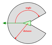
Look around to a distance of "D" for an plus/minus "X" degrees from your current compass bearing:
With that knowledge, work out how much to operate, align, cohere:
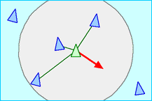 | Separation: steer to avoid crowding local flock mates (give this one the highest priority) |
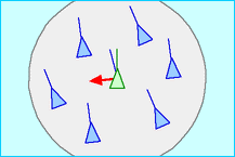 | Alignment: steer towards the average heading of local flock mates |
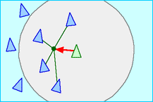 | Cohesion: steer to move toward the average position of local flock mates,
maybe weighted by your compass bearing
741 973 741 |
(See also Lennard-Jones functions for combining the above into one equation.)
Do a weighted sum of the neighborhood, giving a "leader" more weight than the rest of the flock.
Now the problem of programming the flock reduces to just the problem of programming the leader.
Note: the leader can be selected dynamically:
Predict where the food will be, steer towards there.
Predict where the prey will be, steer away from there.
Or, with knowledge of the terrain, find a predator's blind spot (behind a rock) and go steer to there.
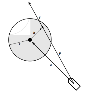
Extend "feelers".
If they fall within "r" of some obstacle, then insert a steering force "b" to deflect the actor
Given a terrain map of regions (rooms, valleys with passes between them, oceans connected by straights),
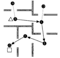
To computer way points:
M1=    A B C D E F G
     A . 1 . . . . .
     B . . 1 . . . .
     C . . . 1 1 . .
     D . . . . . . .
     E . . . . . 1 .
     F . . . . . . 1
     G . . . . . . .
M2=    A B C D E F G
     A . 1 . . . . .
     B 1 . 1 . . . .
     C . 1 . 1 1 . .
     D . . 1 . . . .
     E . . 1 . . 1 .
     F . . . . 1 . 1
     G . . . . . 1 .
If you want some geography, add distance measure instead of just "1"
D1=    A B C D E F G
     A . 4 . . . . .
     B . . 2 . . . .
     C . . . 9 7 . .
     D . . . . . . .
     E . . . . . 8 .
     F . . . . . . 3
     G . . . . . . .
These numbers can reflect difficulty in traversing some region (e.g. mud, quicksand, steep slopes)
Navigation in two steps: go straight to the nearest way point, then path follow from weigh point to weigh point.
 1  function Dijkstra(Graph, source):
 2      for each vertex v in Graph:           // Initializations
 3          dist[v] := infinity               // Unknown distance function from source to v
 4          previous[v] := undefined
 5      dist[source] := 0                     // Distance from source to source
 6      Q := copy(Graph)                      // All nodes in the graph are unoptimized - thus are in Q
 7      while Q is not empty:                 // The main loop
 8          u := extract_min(Q)               // Remove and return best vertex from nodes in two given nodes
                                              // we would use a path finding algorithm on the new graph, such as depth-first search.
 9          for each neighbor v of u:         // where v has not yet been removed from Q.
10              alt = dist[u] + length(u, v)
11              if alt < dist[v]              // Relax (u,v)
12                  dist[v] := alt
13                  previous[v] := u
14      return previous[]
When wondering a path, remember to stagger a little and steer more at corners.
And for crowds to walk paths, add obstable avoidance.
Recall our geograph maps:
D1=    A B C D E F G
     A . 4 . . . . .
     B . . 2 . . . .
     C . . . 9 7 . .
     D . . . . . . .
     E . . . . . 8 .
     F . . . . . . 3
     G . . . . . . .
Remember that these numbers can reflect difficulty in traversing some region (e.g. mud, quicksand, steep slopes)
An inlfuence map is a second "geograohy" map that changes at runtime. E.g. suppose you keep dying everytime you walk from G to A:
Inf=    A B C D E F G
     A . . . . . . .
     B . . . . . . .
     C . . . . . . .
     D . . . . . . .
     E . . . . . . .
     F . . . . . . .
     G 10 . . . . . .
So now we can do A* to minimize g(x)+h(x) where "h=D+Inf"